
Ben Rich and Simon King , Lead Weather Presenters
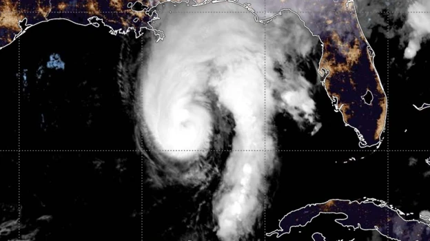
Isaias, the first hurricane of the Atlantic season has been continuing to strengthen and is now a category three ‘major’ hurricane.
Hurricane Hunter aircraft have been flying in and around the storm on Friday morning, now measuring sustained wind speeds of 120mph (193km/h), placing into the higher category.
Isaias will bring damaging winds, torrential rain and a storm surge to parts of the US Gulf Coast with landfall expected late Friday. Hurricane and Storm Surge Watches have been issued.
Isaias brings an end to the lack of hurricanes that has led to a record-breakingly quiet Atlantic season so far with development suppressed by the growing El Niño pattern.
What track will Hurricane Isaias take?
Gaining energy from the very warm waters of the Gulf of Mexico, Hurricane Isaias continues to strengthen.
While now a major hurricane, it is expected to weaken slightly over the next 12 hours to go back to being a high-end category two hurricane.
It will then make landfall on the Gulf Coast, across Alabama and the Florida Panhandle late Friday night and in the early hours of Saturday local time.
After landfall it will head north through Alabama, brushing the east of Missouri during Saturday. While it will quickly weaken to a tropical storm, it will still bring some dangerous winds and flooding rains.

A dangerous storm sturge of up to 6ft is expected in Alabama and Florida, especially around high tide and it will be accompanied by strong winds and large waves.
Between 4 and 8in (101-203mm) of rain is expected in southern Alabama, the Florida panhandle and Big Bend, and southwest Georgia.
A few places could see up to 15in (381mm) with possible flash flooding, especially in urban areas, and the risk of isolated river flooding.
The US National Weather Service has issued Hurricane and Storm Surge Watches along the Gulf Coast.
Florida Governor Ron DeSantis has declared a state of emergency across 25 counties over concerns about potential impacts.
Several major sporting events throughout the region have been cancelled or rescheduled due to the incoming storm. The highly-anticipated football match between the University of Georgia and the University of Alabama – due to be attended by President Donald Trump in the city of Tuscaloosa – is still expected to take place on Saturday.
As the storm moves further inland and loses contact with its warm water fuel source it will weaken. But it is still expected to bring some potentially disruptive wet weather for large swathes of the south-east USA as far north as the Tennessee Valley and the Carolinas.
El Niño brings an eerily quiet hurricane season so far
Forecasters in the US had predicted the 2026 hurricane season would be quieter than average citing the developing strong El Niño in the Pacific Ocean.
An El Niño weather event can lead to more wind shear over the Caribbean and Atlantic, which tears storms apart before they have time to develop.
Whilst lowering the odds of hurricane formation, it does not make it impossible.
Isaias has managed to form in an area with limited wind shear and very high sea temperatures – currently 30 or 31C – giving it the fuel it needs to grow.
Forecasters expect it to encounter more wind shear as it moves northwards which should limit its intensification.
Source: bbc.com